Balancing Environmental Quality and Economic Vitality in the Adirondack Park
Summary
Project started on Jan. 1, 1994 (Completed)
As regulator of land use in New York’s six million acre Adirondack Park, the Adirondack Park Agency (APA) maintains tens of thousands of records about real property, natural resources, and physical and civil infrastructure. Staff depend on these records every day to give advice or make decisions about proposals to buy land, construct buildings, or carry out other development projects. Organizing, finding, and using all of this information effectively has become a critical problem for both the agency and its customers. Gathering the information needed to give an answer or make a decision often consumes more time than the analysis of the request.
During 1994-95, the Center for Technology in Government worked with APA and several corporate and university partners to develop and evaluate a prototype system to combine document records and geographic data into a unified "electronic reference desk." This system allowed agency staff to point at a land parcel displayed on an electronic map and summon legal documents, other maps, project plans, and related information about the property. The prototype evaluation illustrated the financial and staff resources that would be needed to develop and implement a complete system. The project also identified significant potential for internal quality improvements and new customer services.
Scope of Work
New York's Adirondack Park encompasses 12 counties and 105 towns in upstate New York. Whiteface Mountain, Lake Placid, and vast stretches of wilderness share the park with towns and businesses, sportsmen and women, vacationers, and year-round residents.
The Adirondack Park Agency (APA) plays a pivotal, often controversial, role in the life of north country communities. Its mission is to maintain the delicate balance between environmental quality and economic vitality in the region. As regulator of land use over the 3.5 million acres of privately owned land in the Park, the APA maintains tens of thousands of records about real property, natural resources, and physical and civil infrastructure.
These records are kept in filing cabinets, map trays, microfiche jackets, film canisters, boxes, closets, and a few computerized databases that, together with 50 headquarters staff, fill every inch of the building from basement to attic. Staff depend on these records every day to give advice or make decisions about proposals to buy land, construct buildings, or carry on other development projects. The information is important to lawyers, realtors, landowners and developers, researchers, and federal, state, and local governments. Organizing, finding, and using effectively so many different kinds of information has become a critical problem for both the agency and its customers.
Collecting the information needed to give an answer or make a decision often consumes much more time than the analysis of the request. Gathering existing information, rendering geographically-oriented data into a consistent scale, and moving files among different staff specialists take much more time. As a result, it takes several days to respond to a phone inquiry, weeks to make a jurisdictional determination, and months to issue a permit.
During 1994-95, the Center for Technology in Government worked with APA and several corporate and university partners to develop and evaluate a prototype system to combine document records and geographic data into a unified "electronic reference desk" that allows agency staff to point at a land parcel displayed on an electronic map and summon legal documents, other maps, project plans and related information about the property. They may find the parcel by owner name, tax parcel ID, or simple map location. The prototype gathers into one place and one format a wide variety of useful information. Using this prototype, which concentrated on data for land in Essex County, APA staff were able to identify those activities where technology would improve responsiveness and reduce operating costs. The prototype and its evaluation illustrated for the agency the financial and staff resources that would be needed to develop and implement a complete system. The project also identified significant potential for internal quality improvements and new customer services.
Prototype
A key element in this project was the development of a prototype system that would help the agency determine whether a technology solution could help solve their backlog problem, and to help them understand better the expected costs and benefits of developing a system. In this case, a prototype system combining Geographic Information System (GIS) features with document imaging capabilities was developed and evaluated at the agency. This prototype played a key role in helping the agency develop realistic expectations for the technology.
The Problem
In 1994, about 1,000 individuals and businesses asked the APA if it had jurisdiction over their property. When a landowner wants to make an improvement, or a business wants to expand, they need to first ask if the agency has a regulatory interest in their property or proposal before they can begin work.
What kinds of properties does the Agency have interest in? Those near wetlands or other sensitive environmental areas, for example. They are also interested in projects near ones where they have already made some formal determination.
To get a determination from the agency, an individual writes to ask if the agency has jurisdiction over the project (a "Jurisdictional Inquiry" or JIF). The request usually contains a description of the property and the proposed work. A member of the APA staff reviews the application and routes the request to an in-box. Another APA officer finds the tax map, locates the property, then searches for the correct dozen or so maps which relate various data about that area of the park. At a light table, ruler and pencil in hand, the officer does calculations and manipulations to review the characteristics of the parcel.
Once that's done, the officer attempts to locate any information on previous actions in the area of the parcel. This is a long process. Maps and files are all paper-based, and are stored in many places throughout the agency. Much of the data is in archives, which can take days to search. On average, it takes 30 days just to tell the landowner if the agency has jurisdiction. In 80% of the cases, the answer is that the agency has no jurisdiction. 95% of the time needed to make this determination is spent gathering the data.
If jurisdiction is found (as in about 10-20 %) of there cases, there is another, longer period to determine what restrictions may be placed on the project.
The Prototype
The agency sought to speed this process up through the use of an on-line system that provided access to geographic data, geographic analysis tools, paper documents such as deeds and project files, and a workflow system that would handle the JIFs. Given that no commercial off-the-shelf system offered this combination of functionality, it was necessary to build a custom integration of a Geographic Information System (GIS) together with a document management system. Because of the complexity of creating a prototype encompassing all these features, workflow was redesigned, but technical workflow capabilities were left out of the prototype.
The system was designed using Hewlett Packard HP-UX workstations, ESRI's Arc/Info and Arcview2 GIS software, and Excalibur EFS document management system, with links to the agency's existing project databases. The system was populated with a variety of data available to the agency in electronic form, as well as additional information scanned in for the project. This included existing JIF applications, project folders, and tax maps from selected areas in the park.
The prototype was developed by the project team including staff from Computer Sciences Corporation, Hewlett Packard, ESRI, and CTG. It was provided to the agency for evaluation for a period of several months in the project. A more detailed description of the prototype and its development process is contained in Using Technology to Change Work: Technical Results from the APA Prototype
How the Prototype Works
Expanded View of Slide The prototype is no longer operational, but the following scenario captures the essence of how it functioned. The screen shots show what a user would see. Say Lakewood Properties owns a piece of land in North Elba (which is in mid-park, near Lake Placid). The owner, Mr. James McNamara wants to know if he can build a new structure on his land. The county planning office has reminded him that he needs to get an OK from the APA before a building permit is issued.
Using the workstation, the agency can quickly collect the data needed to make a formal determination. When Mr. McNamara comes to the APA, a desk officer asks him for information about the property.
Expanded View of Slide Assume Mr. McNamara doesn't know his tax map information. The officer can search the existing database index of parcels for his name. Finding a record, he can ask, "is this the parcel just north of Rt. 86?" to confirm that they have the right location.
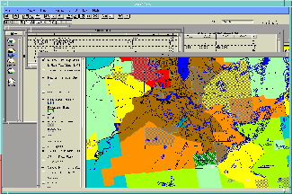
From the link to the GIS system, the officer can call up a map window that is focused on the parcel of land in question. The parcel is identified by a yellow dot indicating the parcel centroid which has the name "McNamara James" in its record.
Once the agency confirms that it's looking at the right parcel (possibly with Mr. McNamara still on the phone), it can start collecting data. First, the background color indicates that the parcel falls into a low intensity use area, which has some levels of restrictions. Next, the extent of the parcel's boundaries can be determined by looking at the current tax map.
Expanded View of Slide The agency can add additional information it needs to conduct its review. It can, for example, review the ecological information around that parcel. It might see that there are wetlands, about 100 meters away from the edge of the parcel.
All this can be done in the initial contact with Mr. McNamara. If he'd like a copy, the agency can print our maps to show him what they have found.
All GIS functionality is present: zooming and panning, moving to other areas of the map, adding and removing different types of information ("layers") to the view. The agency's databases can be used to locate information about other parcels that may be pertinent.
Expanded View of Slide So far, everything the agency has done is within the realm of the GIS. An important piece of information that is needed to make a determination of jurisdiction is the prior history of the parcel. Boundaries of previous permitted projects have been rasterized and stored in the database. If the agency turns on that coverage, they can see that the centroid (the geographic center of the property) falls within an earlier project. The agency can select that project and issue a request to see the project data. The request is passed to the document image software, which shows that the parcel was part of a subdivision.
Expanded View of Slide In this case, the project document was the original subdivision. Often the terms of the subdivision may contain restrictions on the types of actions which may be taken on the property. Once the agency retrieves the document, it can be printed and attached to copies of the earlier findings.
After evaluating the prototype, the Adirondack Park Agency determined that the combination of on-line map data and file information would be sufficient to approve the great majority of requests without further action. Instead of passing paper and collecting data over weeks, it could accomplish the same work in minutes.

Press Releases & News Stories
Press Release
Publications & Results
Reports
- A Survey of Key Concepts and Issues for Electronic Recordkeeping
- Balancing Environmental Quality and Economic Vitality in the Adirondack Park
- Evaluating the APA Prototype: Prospects for Providing Cheaper, Faster, and Better Services to the APA's Customers
- Using Technology to Change Work: Technical Results from the APA Prototype
Lessons Learned
The project results hold many lessons that are of value to any government organization facing similar problems regarding prototyping, land records, data development, and the need to integrate and manage information in a variety of formats. The project generated insights into the use of prototyping, geographic information systems, spatial data and document imaging which are useful to any government organization.
The sooner a prototype is developed, the more it can stimulate creative problem solving. In this regard, a quickly-developed prototype is better than one with more features that takes longer to construct. Introducing agency staff to a stripped down technology solution, loaded with their own data, is a powerful catalyst for creativity. Subsequent project activities, including the final prototype design and the modeling and benefit analyses, are much more grounded in reality because staff have seen the technology in action and have developed some confidence in its potential by having experienced first-hand how it might work.
A prototype is a valuable tool to focus attention on non-technical issues. In defining the workflow to be automated in a prototype, agency staff must discuss what they actually do in performing their jobs. This produces a better understanding of how those jobs can be changed (with and without the technology) to improve service. A prototype system can then serve as a powerful focus for discussion of important agency business problems and help direct attention to key policy and management questions: What is the problem we're trying to solve? How do we currently attack the problem? What do we need to be able to solve the problem? How will we measure improvement? Who will benefit? While these questions don't require a prototype to answer, having a prototype in hand shows how information, processes, and technology work together.
The automated permit retrieval system prototype demonstrates a unique model for integrated records management and land information systems. A number of states and counties have sought to improve land records management and the related services they provide. The APA system is a first attempt to manage integrated records across different physical media and institutional sources. Other governments struggling with disparate types and forms of data will benefit from knowing more about the core technologies and information management techniques explored in this project.
A coherent data development and management strategy is essential to the success of any system which relies on a variety of data formats and sources. No system is better than the quality, integrity, and consistency of the data it contains. The project demonstrated the importance of having a clear picture of an organization's data resources and a well-articulated data management program. Some key program elements include sufficient metadata to describe datasets, consistent coding schemes for related data, data modeling to identify and make use of the relationships among data elements and data types, and recognition that data resources belong to the entire organization and should not become isolated in separate work units or program areas.
Use of existing spatial or tabular data is a simple, quick, and cost-effective method of populating a new geographic information system (GIS) with data, but users must be aware of the special problems presented by temporal inconsistencies and scale variability across different data sources. Use of existing data is particularly desirable when prototyping, since it enables a prototype system to become functional in far less time than when data must be acquired from outside sources. However, both time of data creation and scale of physical representation are sources of unavoidable inaccuracy when different data layers are used in concert. This problem is manageable if well-documented and well-understood by users.
Service bureaus that perform document conversion provide highly specialized services; the services offered, quality of results, and prices charged are likely to vary widely. Choice of vendor may be strongly influenced by the output file formats they are able to provide and their ability to be read by image display software. In addition, tight quality control is needed at every step of the document conversion process. Sending sample data to several vendors is highly recommended; in this way image quality, job pricing, file storage requirements, and timeliness of delivery may be evaluated. Several vendors, each with a specific area of expertise, may be needed to complete a complex document conversion process.
Partners
Government Partners
- New York State Adirondack Park Agency
Corporate Partners
- Bay Networks, now known as Nortel Networks
- Computer Sciences Corporation
- ESRI
- Excalibur, now known as Convera
- Hewlett-Packard
- NYNEX (now known as Verizon)
- Oracle Corporation
- Xyplex, Inc., now known as MRV Communications, Inc.
Academic Partners
- David Andersen, Distinguished Service Professor, Department of Public Administration and Policy, Rockefeller College of Public Affairs and Policy, University at Albany, SUNY
- John Rohrbaugh, Professor, Department of Public Administration and Policy, Rockefeller College of Public Affairs and Policy, University at Albany, SUNY
Center for Technology in Government
- Peter Avery, Project Coordinator
- Donna Berlin, Facilities Manager
- Peter Bloniarz, Research Director
- Anne Miller, Graduate Assistant
- Paul Husek, Graduate Assistant
- Steven Hyde, Graduate Assistant
- Kristine Kelly, Research Associate
- Soonhee Kim, Graduate Assistant
- Eliot Rich, Research Associate
Funding Sources
This project was funded by a portion of CTG's New York State budget allocation plus in-kind contributions of professional services, hardware, software, and communications provided by the Adirondack Park Agency, University at Albany faculty members, and corporate partners.